Metrô
Lines 1, 2 and 4 connect Ipanema, Copacabana, Botafogo, Centro and Zona Norte. Mon to Sat from 5am to midnight; Sundays and holidays from 7am to 11pm.
Official website
Mobility
Metro, VLT, BRT, train, ferries, bicycle and ride apps: choose an origin and destination and see the best route across the city.
Plan your public transport route with Moovit, the city's official transport app. Enter your origin and destination below and the app builds the route.
Choose origin and destination
Enter the address, attraction or the departure and arrival station.
Compare the routes
Metro, BRT, VLT, bus and ferries with schedules and travel time.
Follow in real time
Track the vehicle, connections and operation alerts.
BRT, VLT, train and metro. Understand how the modes connect and plan your transfers before heading out.
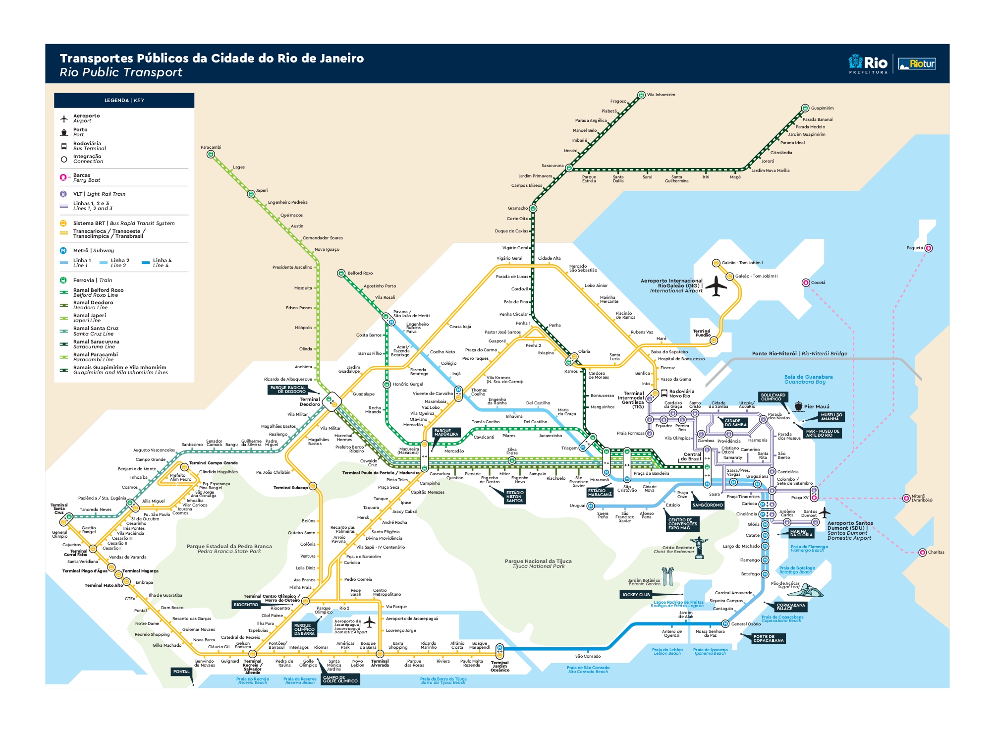
For more information on mobility, visit the public transport companies' websites.
Lines 1, 2 and 4 connect Ipanema, Copacabana, Botafogo, Centro and Zona Norte. Mon to Sat from 5am to midnight; Sundays and holidays from 7am to 11pm.
Official websiteMunicipal network covering the whole city, with payment by electronic or contactless card.
Official websiteConnects the Novo Rio bus terminal, Praça Mauá and Santos Dumont Airport, passing by the museums in Centro.
Official websiteMetropolitan trains to Zona Norte, Baixada Fluminense and Japeri, with connections at Central station.
Official websiteExpress corridors between Galeão, Barra da Tijuca and Zona Oeste. The airport line runs 24 hours, every 20 minutes.
Official websiteFerry crossings to Niterói and Paquetá departing from Praça XV, with the best view of Guanabara Bay.
Official websiteOver 450 km of bike lanes connect Ipanema to Aterro do Flamengo and Centro, with shared bike stations along the waterfront.
Tip: On Sundays the waterfront is closed to cars — the best day to ride.
Yellow taxis with rate 1 (Mon to Sat, 6am to 9pm) and rate 2 (9pm to 6am, Sundays and holidays). Ride apps operate 24 hours.
Tip: At the airports, use only the official signposted taxi stands.
Especial Coop offers wheelchair-adapted vehicles, bookable by phone.
Tip: (+55 21) 3295-9606 · (+55 21) 98936-0946
International and domestic flights. 24-hour BRT to Barra and executive bus to Zona Sul in about 50 minutes.
In Centro, right on the Bay. Air shuttle to São Paulo and Brasília, 10 minutes from Cinelândia by VLT.
Routes to the whole country, connected to the VLT and metro at Central station.
Need official phone numbers, accessible taxis or detailed schedules? Check the useful information page.